Golden Integration is a company that specializes in providing geophysical equipment and solutions for various applications, including exploration, environmental studies, engineering, and research.,
Golden Integration provide product ranges and categories of geophysical equipment, These product ranges include:
1. Seismic Equipment
Seismic methods are widely used for subsurface exploration and imaging. Golden Integration may offer:
- Terraloc Pro range from Guideline Geo AB
2. Electrical Resistivity and Induced Polarization (IP) Systems
These techniques are used for mapping subsurface structures based on electrical properties.
- Terrameter LS 2 products range from Guideline Geo AB
3. Ground Penetrating Radar (GPR)
GPR is used for shallow subsurface imaging in applications like archaeology, utility detection, dams, concrete inspection and more….
- MALA Products range from Guideline Geo AB
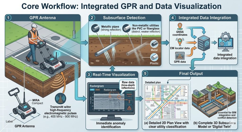
Core Workflow: Integrated GPR and Data Visualization
Our technical capabilities for subsurface mapping rely on a structured process where diverse sensor data is combined to generate high-definition models. A critical component is Ground Penetrating Radar (GPR), which non-destructively images the subsurface.
The following illustration visualizes this comprehensive workflow, from field data acquisition to the final processed output.
Description of Workflow Stages:
- GPR Antenna: An operator moves the GPR unit (like the MALÅ MIRA Compact) over the survey area. The system transmits high-frequency electromagnetic pulses (e.g., 400 MHz – 900 MHz) into the ground.
- Subsurface Detection: These pulses reflect off materials with different dielectric properties. The diagram must highlight that both metallic pipes (strong reflection) and non-metallic utilities like PVC or fiberglass (distinct, weaker reflection) are detected.
- Real-Time Visualization: The raw data (time-depth reflections) is collected and instantly processed into a “Radargram” (a 2D cross-section), allowing for immediate anomaly identification in the field.
- Integrated Data Integration: For complete context, positional data (GNSS coordinates) and other sensor inputs (like EM locator data) are fused with the GPR information.
- Final Output: This integrated data is processed and visualized, resulting in (a) a detailed 2D Plan View with clear utility classification, and (b) a complete 3D Subsurface Model or “Digital Twin,” which is essential for BIM integration and conflict detection.
4. Magnetotlluric
Magnetotlluric methods are used for mapping subsurface conductivity and are particularly useful in Oil & Gas exploration, Geothermal exploration, Mineral exploration, Deep crustal research and groundwater studies.
- Magnetotlluric from our partner Phoenix geophysics.
Applications of Golden Integration’s Equipment
The products offered by Golden Integration can be applied across various industries, including:
- Mineral Exploration : Identifying ore bodies and mineral deposits.
- Oil and Gas Exploration : Mapping reservoirs and fault structures.
- Environmental Studies : Assessing contamination and groundwater resources.
- Engineering and Construction : Site characterization and foundation studies.
- Archaeology : Locating buried artifacts and structures.